Lidar News Weekly RECAP – August 18-21st

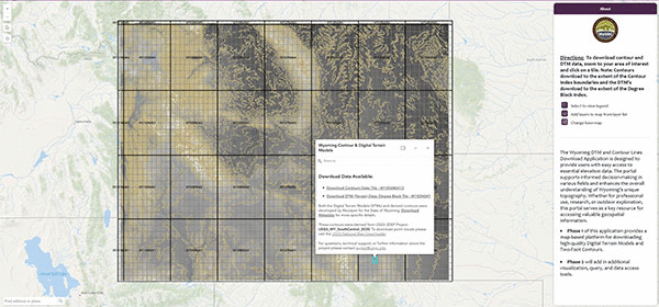
Lidar News Weekly RECAP – August 18-21st Curated and written by Adam Clark. Adam has spent the past 13 years exploring the world from above by using drones, satellites, and mapping tools to better understand our landscapes. A Fresh Look at Decommissioning & Offshore Wind Projects Through 3D Vision Voyis’ Discovery Stereo Vision System empowers ROVs with genuine 3D perception by […]

Read more

Lidar News Weekly RECAP – August 11-14th

Curated and written by Adam Clark. Adam has spent the past 13 years exploring the world from above by using drones, satellites, and mapping tools to better understand our landscapes. Full size cave 3D modelling using close range photogrammetry and comparison with laser scanning Although underground topography methods have advanced over the past two decades, generating comprehensive 3D cave models remains […]

Read more

Lidar News Weekly RECAP – August 4th

Lidar News Weekly RECAP – August 4th Curated and written by Adam Clark. Adam has spent the past 13 years exploring the world from above by using drones, satellites, and mapping tools to better understand our landscapes. ────────────── AlphaEarth Foundations helps map our planet in unprecedented detail DeepMind’s new AI, AlphaEarth Foundations, acts like a “virtual satellite” by integrating petabytes of […]

Read more

LIDAR NEWS WEEKLY RECAP – JULY 28th

LIDAR NEWS WEEKLY RECAP – JULY 28th Curated and written by Adam Clark. Adam has spent the past 13 years exploring the world from above by using drones, satellites, and mapping tools to better understand our landscapes. AEye Unveils OPTIS™, a Physical AI Platform for Next-Gen Smart Mobility AEye, Inc. has launched OPTIS, a comprehensive physical AI platform powered by NVIDIA […]

Read more

Nortek Nucleus Supports Coral Reef Photogrammetry Project

Nortek Nucleus Supports Coral Reef Photogrammetry Project Synopsis written by Adam Clark. Adam has spent the past 13 years exploring the world from above by using drones, satellites, and mapping tools to better understand our landscapes. A collaborative team of academics, supported by Inkfish, deployed Seeker autonomous underwater vehicles (AUVs) equipped with Nortek Nucleus 1000 navigation sensors off Tonga to map […]

Read more

LIDAR NEWS WEEKLY RECAP – JULY 21st

Curated and written by Adam Clark. Adam has spent the past 13 years exploring the world from above by using drones, satellites, and mapping tools to better understand our landscapes. AMETEK Completes Acquisition of FARO Technologies, Strengthening Leadership in 3D Metrology, Laser Projection & Digital Reality Solutions AMETEK, Inc. has finalized its acquisition of FARO Technologies. FARO is known for its […]

Read more

3D Reconstruction of Underwater Shipwrecks

3D Reconstruction of Underwater Shipwrecks: 3D Gaussian Splatting and Structure from Motion for the Melania shipwreck Summary written by Adam Clark. Adam has spent the past 13 years exploring the world from above by using drones, satellites, and mapping tools to better understand our landscapes. Researchers from the University of Pisa and Arts et Métiers apply two image‑based 3D reconstruction methods Structure […]

Read more

LIDAR NEWS WEEKLY RECAP – JULY 14th

LIDAR NEWS WEEKLY RECAP – JULY 14th Curated and written by Adam Clark. Adam has spent the past 13 years exploring the world from above by using drones, satellites, and mapping tools to better understand our landscapes. Lidar sensors are paving the way to more connected – and safer – roads New research into utilizing LiDAR to detect and monitor vehicles, […]

Read more

Mapping the Largest Known Cold-Water Coral Reef Habitat

Mapping the Largest Known Cold-Water Coral Reef Habitat Synopsis written by Adam Clark. Adam has spent the past 13 years exploring the world from above by using drones, satellites, and mapping tools to better understand our landscapes. Hydro International reports on an extraordinary seafloor mapping missions revealing the world’s largest known cold-water coral reef habitat off Greenland, spanning over 10,000 square miles. […]

Read more

Lidar News Weekly Recap – July 7th

Curated and written by Adam Clark. Adam has spent the past 13 years exploring the world from above by using drones, satellites, and mapping tools to better understand our landscapes.Turning 3D Reality Capture into Life-Saving Intelligence Geo Week News highlights how 3D reality capture technologies like LiDAR and photogrammetry transform emergency response for law enforcement, fire service, and paramedics. Fast, […]

Read more

New UW Online Portal Opens Access to Statewide LiDAR Data

New UW Online Portal Opens Access to Statewide LiDAR Data Synopsis Written by Adam Clark The University of Wyoming’s Wyoming Geographic Information Science Center (WyGISC) has launched a new, free public Wyoming LiDAR Data Portal, offering statewide high-resolution digital terrain models and 2‑foot contours. Funded by a $2 million legislative appropriation in 2023 and developed with Woolpert, the portal centralizes LiDAR-derived […]

Read more
1 2