Lidar in Transportation: National Academies Publish New Report

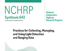
LiDAR in Transportation: National Academies Publish New Report The National Academies of Sciences, Engineering, and Medicine have released a significant new resource for the transportation and geospatial communities: NCHRP Synthesis 642 – Practices for Collecting, Managing, and Using Light Detection and Ranging (LiDAR) Data. Published through the Transportation Research Board’s National Cooperative Highway Research Program (NCHRP), this 210-page synthesis offers […]

Read more

USGS Calls for Next-Gen Mapping Strategy

Charting the Future of 3D Topography: USGS Calls for Next-Gen Mapping Strategy As geospatial technologies continue to evolve, so too must the systems that support our understanding of the terrain beneath our feet. The U.S. Geological Survey (USGS) has released Circular 1553, a strategic document outlining the future of national elevation and hydrography data under the evolving 3D National Topography […]

Read more

Nortek Nucleus Supports Coral Reef Photogrammetry Project

Nortek Nucleus Supports Coral Reef Photogrammetry Project Synopsis written by Adam Clark. Adam has spent the past 13 years exploring the world from above by using drones, satellites, and mapping tools to better understand our landscapes. A collaborative team of academics, supported by Inkfish, deployed Seeker autonomous underwater vehicles (AUVs) equipped with Nortek Nucleus 1000 navigation sensors off Tonga to map […]

Read more

LIDAR NEWS WEEKLY RECAP – JULY 21st

Curated and written by Adam Clark. Adam has spent the past 13 years exploring the world from above by using drones, satellites, and mapping tools to better understand our landscapes. AMETEK Completes Acquisition of FARO Technologies, Strengthening Leadership in 3D Metrology, Laser Projection & Digital Reality Solutions AMETEK, Inc. has finalized its acquisition of FARO Technologies. FARO is known for its […]

Read more

3D Reconstruction of Underwater Shipwrecks

3D Reconstruction of Underwater Shipwrecks: 3D Gaussian Splatting and Structure from Motion for the Melania shipwreck Summary written by Adam Clark. Adam has spent the past 13 years exploring the world from above by using drones, satellites, and mapping tools to better understand our landscapes. Researchers from the University of Pisa and Arts et Métiers apply two image‑based 3D reconstruction methods Structure […]

Read more

LIDAR NEWS WEEKLY RECAP – JULY 14th

LIDAR NEWS WEEKLY RECAP – JULY 14th Curated and written by Adam Clark. Adam has spent the past 13 years exploring the world from above by using drones, satellites, and mapping tools to better understand our landscapes. Lidar sensors are paving the way to more connected – and safer – roads New research into utilizing LiDAR to detect and monitor vehicles, […]

Read more

Mapping the Largest Known Cold-Water Coral Reef Habitat

Mapping the Largest Known Cold-Water Coral Reef Habitat Synopsis written by Adam Clark. Adam has spent the past 13 years exploring the world from above by using drones, satellites, and mapping tools to better understand our landscapes. Hydro International reports on an extraordinary seafloor mapping missions revealing the world’s largest known cold-water coral reef habitat off Greenland, spanning over 10,000 square miles. […]

Read more

Lidar News Weekly Recap – July 7th

Curated and written by Adam Clark. Adam has spent the past 13 years exploring the world from above by using drones, satellites, and mapping tools to better understand our landscapes.Turning 3D Reality Capture into Life-Saving Intelligence Geo Week News highlights how 3D reality capture technologies like LiDAR and photogrammetry transform emergency response for law enforcement, fire service, and paramedics. Fast, […]

Read more

New UW Online Portal Opens Access to Statewide LiDAR Data

New UW Online Portal Opens Access to Statewide LiDAR Data Synopsis Written by Adam Clark The University of Wyoming’s Wyoming Geographic Information Science Center (WyGISC) has launched a new, free public Wyoming LiDAR Data Portal, offering statewide high-resolution digital terrain models and 2‑foot contours. Funded by a $2 million legislative appropriation in 2023 and developed with Woolpert, the portal centralizes LiDAR-derived […]

Read more

Lidar News Weekly Recap – Week of June 29th

Written by Adam Clark New UW Online Portal Opens Access to Statewide LiDAR Data The University of Wyoming’s Wyoming Geographic Information Science Center (WyGISC) has launched a new, free public Wyoming LiDAR Data Portal, offering statewide high-resolution digital terrain models and 2‑foot contours. Funded by a $2 million legislative appropriation in 2023 and developed with Woolpert, the portal centralizes LiDAR-derived elevation […]

Read more

Bathymetric Lidar Webinar Replay Available Now

We had a great discussion on Friday with a panel of experts and over 95 attendees joining us live. The session covered important topics, addressed key challenges, and featured insightful questions from the audience—expertly answered by our panelists. If you missed it, be sure to catch the replay now on YouTube! https://www.youtube.com/watch?v=2cZtLHOMgMs 🔍 Topics include: 🎙 Expert Panelists: 🎤 Moderator:

Read more

Advances In LiDAR And Radar Accelerate Driving Autonomy

Advances In LiDAR And Radar Accelerate Driving Autonomy – Forbes Magazine recently posted this article by Sabbir Rangwala The article explores how recent advances in lidar and radar technologies are accelerating the development of autonomous driving. While lidar provides highly accurate 3D mapping crucial for object detection, radar has evolved—especially with imaging and 4D radar—offering improved resolution, cost-efficiency, and performance […]

Read more

Free Webinar: Bathymetric Lidar and Beyond – Hosted by Lidar News

Webinar will be interactive including Q & A. 🔍 Topics include: 🎙 Expert Panelists: 🎤 Moderator: Sign up Here: https://us06web.zoom.us/webinar/register/3317500544747/WN_3mzjp5_xTa265aA4PQnS2w#/registration Replay is available. We will send the link to registrants. Stay up-to-date. Subscribe to the Lidar News eNewsletter * indicates required First Name Last Name Email Address * Job Title Subscription All Lidar News Content Weekly Newsletter Daily Blog Posts […]

Read more

GeoCue and Maine Technical Source Announce Strategic Partnership to Expand LiDAR Technology Across New England

GeoCue and Maine Technical Source Announce Strategic Partnership to Expand LiDAR Technology Across New England New distributor to bring TrueView LiDAR sensors and LP360 software to the Northeastern U.S. For Release June 16, 2025 Huntsville, AL – GeoCue, a leading provider of advanced LiDAR mapping hardware and software solutions, proudly announces its strategic expansion into New England through a partnership […]

Read more

LIDAR and Local Wisdom Reveal Forgotten City

LIDAR and Local Wisdom Reveal the Forgotten Portuguese City Beneath the Amazon’s Canopy Reported in MSN this week: “We were able to identify the layout of the streets of this city, which was also a fascinating discovery,” Eduardo Neves, director of the University of São Paulo’s Museum of Archaeology and Ethnography, said in a statement that captures the understated excitement […]

Read more

New DJI Enterprise Drone: Matrice 400

DJI Matrice 400 Rescue

DJI Matrice 400 Sets New Standard for Intelligent and Efficient Long-Endurance Aerial Missions Enterprise Flagship Drone Platform Enhanced with Extended Flight Time, Intelligent Power-Line–Level Obstacle Sensing, and Heavier Payload Capacity June 10, 2025 – DJI, the global leader in civil drones and creative camera technology, today introduces DJI Matrice 400 as the company’s new enterprise flagship drone platform. It boasts an […]

Read more

Bridger Photonics – Offshore Drone-Based Methane Detection

Bridger Photonics Rolls Out Offshore Drone-Based Methane Detection Bridger Photonics is now deploying a compact version of its Gas Mapping LiDAR (GML) system on heavy-lift drones to monitor methane emissions from offshore oil and gas infrastructure—especially platforms and LNG facilities that are difficult for traditional aircraft to access dronedesk.io+15dronelife.com+15dronelife.com+15 Why drones? How it works:Teams transport the drone and sensor via […]

Read more

Lidar Laboratory at Tampa Airport

Creating a first-of-its-kind Lidar laboratory at Tampa International Airport Thank you to International Airport Review Doug Wycoff, Director of Digital Solutions and Innovation at Tampa International Airport, spoke with International Airport Review about the airport’s most recent innovations, including its LiDAR laboratory and their plans for a ‘dream’ baggage handling system. ~~~ What trends have you been observing among your […]

Read more

RIEGL Webinar Announcement: Precision & Proof – Leveraging the VZ-600i in Forensics

RIEGL Webinar Announcement: Precision & Proof – Leveraging the VZ-600i in Forensics Register Now for the next RIEGL Ultimate LiDARTM webinar featuring the VZ-600i, showcasing its cutting-edge hardware and software capabilities for crime and crash scene forensics. Secure your spot today and gain valuable insights from Bryan Menendez, West Coast Business Development for RIEGL USA and Bryon O’Neil, Traffic Crash Reconstructionist for […]

Read more

QCi Lands $406K Subcontract to Support Space-Based LiDAR Data Analysis for NASA

QCi, an integrated photonics and quantum optics technology company, announced that the Company has been awarded a subcontract with a ceiling value of $406,478 to support the National Aeronautics and Space Administration’s (NASA) Langley Research Center through the development of an innovative quantum computing technique for removal of solar noise from space lidar data. QCi received the subcontract award through Analytical Mechanics Associates (“AMA”), a prime […]

Read more

BSI Engineering and Surveying Makes a LiDAR Triple Play in New Episodes of Down to Earth

BSI Engineering and Surveying Makes a LiDAR Triple Play in New Episodes of Down to Earth See How One Surveying Firm Uses Aerial, Mobile, and Handheld LiDAR to Expand Their Business Huntsville, AL – GeoCue announces the premiere of a new three-part edition of its award-winning drone surveying reality series, Down to Earth. The latest episodes feature BSI Engineering and […]

Read more

Using RIEGL LiDAR to Understand How Forests Mitigate Climate Change

Using RIEGL LiDAR to Understand How Forests Mitigate Climate Change Understanding the impacts of forest disturbances on forest structure – and consequently, their capacity to buffer climate change impacts by regulating microclimates and mitigating climate extremes – is crucial for predicting how forests will respond to climate change. However, the full extent of these impacts remains poorly understood, especially across […]

Read more

Canadian Summer Internship Program Trains Hydrographers of the Future

Canadian Summer Internship Program Trains Hydrographers of the Future By Kevin P. Corbley Three marine organizations teamed in the summers of 2023 and 2024 to prepare Canadian ocean mapping students to become “Hydrographers of the Future.” The first-of-its-kind internship program focused on equipping the students with the technical skills and knowledge that are increasingly required in the hydrography profession but […]

Read more

How to Generate a Digital Terrain Model from a LiDAR Point Cloud: Complete Workflow

How to Generate a Digital Terrain Model from a LiDAR Point Cloud: Complete Workflow May 8, 2025 Digital Terrain Model (DTM) generation  from LiDAR point clouds is a fundamental process in geospatial engineering, supporting applications such as flood modeling, infrastructure planning, environmental monitoring, and terrain analysis. Although the task may seem simple at first glance, it encompasses a sequence of […]

Read more

BCIT to Host Surveying and Geomatics Educators Society (SaGES) Conference

BCIT to Host Surveying and Geomatics Educators Society (SaGES) Conference [Vancouver, B.C.] British Columbia Institute of Technology (BCIT) is pleased to host the 29th biennial conference of the Surveying and Geomatics Educators Society (SaGES) from June 15 to 19, 2025, at the BCIT Downtown Campus in Vancouver, B.C.  The SaGES 2025 Conference will welcome approximately 100 attendees, including educators, professionals, and technology leaders […]

Read more
1 2 3 76